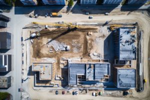
How Aerial Survey Services are Revolutionizing Land Management in Palm Beach County
In today’s rapidly evolving world, technology plays a crucial role in various industries, and land management is no exception. Land developers, government agencies involved in infrastructure planning projects or conservation efforts like parks departments, urban planners, and architects are constantly seeking innovative solutions to improve their operations. One such solution that has gained significant popularity is the use of aerial survey services, including drone technology and 3D mapping capabilities. These services are revolutionizing land management practices in Palm Beach County by offering numerous benefits over traditional methods.
1. Increased Accuracy
Aerial survey services provide a level of accuracy that was previously unattainable with traditional land surveying techniques. Drones equipped with high-resolution cameras and LiDAR (Light Detection and Ranging) sensors capture precise data points from above, resulting in highly accurate measurements and detailed visual representations of the land. This accuracy is essential for tasks such as boundary surveys, topographic mapping, and infrastructure planning.
2. Cost-Effective Solutions
Compared to conventional land surveying methods that often involve large teams of surveyors on the ground, aerial survey services offer a cost-effective alternative. Drones can cover large areas quickly and efficiently, reducing labor costs significantly. Additionally, the use of drones eliminates the need for expensive equipment like total stations or GPS receivers traditionally used for land surveys.
3. Reduced Environmental Impact
Palm Beach County is home to diverse ecosystems that require careful consideration during any land management activities. Aerial survey services minimize the environmental impact by reducing ground disturbance. Traditional methods often require clearing vegetation or creating access roads for surveyors to reach remote areas, potentially disrupting habitats and causing soil erosion. With drones, data collection can be carried out without disturbing sensitive ecosystems.
4. Time-Saving Processes
Time is a valuable resource in any land management project. Aerial survey services enable faster data collection and processing compared to traditional methods. Drones can cover large areas in a fraction of the time it would take for ground-based surveyors. Furthermore, the data collected by drones can be processed quickly using advanced software, allowing land managers to access accurate and up-to-date information promptly.
In addition to these primary benefits, aerial survey services offer several other advantages that enhance land management practices in Palm Beach County:
- Improved Safety: By utilizing drones for data collection, land managers can reduce the risks associated with sending surveyors into hazardous or inaccessible areas.
- Enhanced Visualization: 3D mapping capabilities provide a comprehensive view of the land, enabling better decision-making and planning.
- Increased Efficiency: The integration of aerial survey services into existing workflows streamlines processes and improves overall efficiency.
To fully leverage the benefits of aerial survey services, it is crucial for land developers, government agencies, urban planners, and architects in Palm Beach County to collaborate with experienced professionals who specialize in utilizing drone technology and 3D mapping capabilities. These experts can assist in designing customized surveys tailored to specific project requirements and provide valuable insights based on the collected data.
In conclusion, aerial survey services are revolutionizing land management practices in Palm Beach County. With increased accuracy, cost-effective solutions, reduced environmental impact on sensitive ecosystems, and time-saving processes compared to traditional methods, these services offer significant advantages. By embracing this innovative technology, land developers, government agencies involved in infrastructure planning projects or conservation efforts like parks departments, urban planners, and architects can enhance their operations and make informed decisions for sustainable land management.


Leave a Reply
Your email is safe with us.